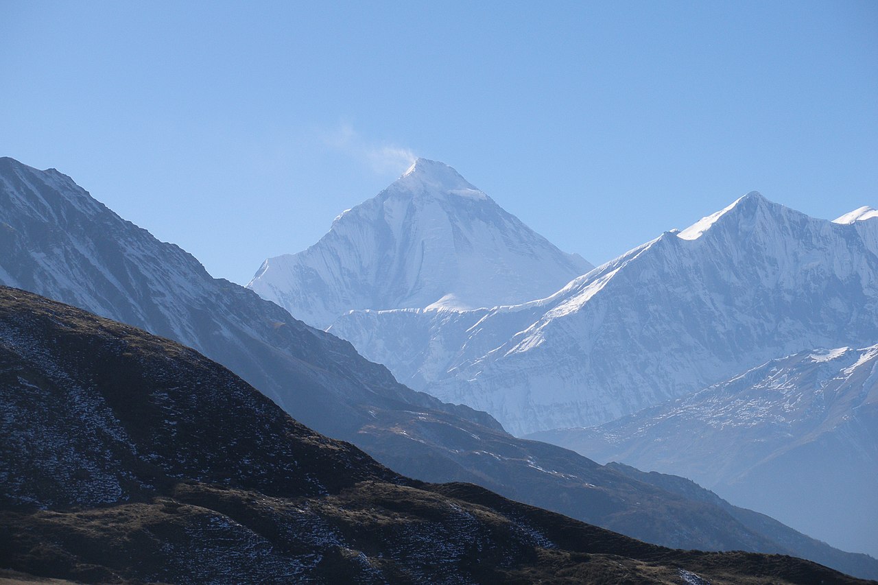
The Dhaulagiri Circuit Trek is a 22-day trip in Jomsom, Mustang (fly to Pokhara or drive via Beni), reaching a maximum elevation of French Pass, 5,360 m (17,585 ft). The best time to do this trip is Late September - early November; late April - late May. The package includes group sizes of Minimum 2 trekkers (remote safety requirement), fully supported camping (sleeping tents, kitchen tent, dining tent provided); teahouse at beni, darbang, marpha, jomsom accommodation, all breakfasts, lunches, and dinners during the camping section; teahouse meals at start/end.
| Country | Jomsom, Mustang (fly to Pokhara or drive via Beni) |
|---|---|
| Max Elevation | French Pass, 5,360 m (17,585 ft) |
| Duration | 22 |
| Best Time | Late September - early November; late April - late May |
| Meals | All breakfasts, lunches, and dinners during the camping section; teahouse meals at start/end |
| Accommodation | Fully supported camping (sleeping tents, kitchen tent, dining tent provided); teahouse at Beni, Darbang, Marpha, Jomsom |
| Group Size | Minimum 2 trekkers (remote safety requirement) |
How long is the Dhaulagiri Circuit trek?
The Dhaulagiri Circuit Trek is one of Nepal's most demanding and rewarding wilderness journeys, a 22-day horseshoe route that circumambulates Dhaulagiri (8,167 m) - the world's seventh-highest peak - through landscapes so remote that many sections see fewer than three hundred trekkers per year. The circuit begins in the subtropical Myagdi River valley at Beni (830 m) and climbs relentlessly through rhododendron forests, alpine meadows, and glaciated moraines before cresting the French Pass at 5,360 metres and descending through the ethereal Hidden Valley into the rain shadow of the Mustang plateau, finishing at the ancient Thakali town of Marpha (2,670 m) in the Kali Gandaki gorge.
The defining section is the crossing from Italian Base Camp (5,100 m), used by Dhaulagiri expeditions since 1960, over the French Pass (5,360 m) and down through Hidden Valley (5,100 m) - a three-day high-altitude traverse above 5,000 metres. Trekkers walk beneath the sheer five-kilometre south face of Dhaulagiri, cross the Chonbarden Glacier, and emerge into a high-altitude valley rimmed by Tukuche Peak (6,920 m), Dhampus Peak (6,012 m), and the Mukut Himal chain. The sense of solitude, scale, and wildness here is unlike anything on Nepal's mainstream trekking routes.
Because the circuit passes through no permanent settlements above Jyardan (2,000 m) on the climb and Dhaulagiri BC (4,750 m) on the traverse, View Himalaya operates this route as a fully-supported camping expedition: all tents, sleeping mattresses, a cook team, and a kitchen tent are carried on the trek. This logistical self-sufficiency is what makes the circuit possible and safe, enabling proper rest and hot meals at altitude far from any teahouse.
| Group Size | Price per Person (USD) | Includes |
|---|---|---|
| Solo | Not available | Minimum 2 trekkers - remote terrain safety policy |
| 2 people | USD 2,699 | All camping, guide, cook team, permits, Pokhara - Beni - Jomsom transport |
| 3 - 5 people | USD 2,499 | All camping, guide, cook team, permits, Pokhara - Beni - Jomsom transport |
| 6 - 10 people | USD 2,299 | All camping, guide, cook team, permits, Pokhara - Beni - Jomsom transport |
| 11+ people | Contact us | Custom group pricing available |
A 20% deposit confirms your booking. The balance is payable 45 days before departure. The Jomsom - Pokhara flight (approximately USD 95 - 110) is not included in the package price and is booked locally based on weather and availability; a direct jeep return to Pokhara (5 - 6 hours via Beni) is available as an alternative at lower cost.
The Dhaulagiri Circuit is not for the faint-hearted. The approach along the Myagdi Khola from Beni to Jyardan is long, hot, and repeatedly crosses swaying suspension bridges over glacial torrents. The gradient stiffens sharply above Jyardan as the trail climbs through dense rhododendron and oak forest to the high alp at Chhonhbardan (3,800 m), then onto the lateral moraine of the Chonbarden Glacier. By the time you reach Italian Base Camp at 5,100 m, you will have gained over 4,270 vertical metres from the trailhead. Two acclimatisation nights are built into the circuit - one at Chhonhbardan (3,800 m) for a rest day with exploration, and one at Italian BC before the pass crossing.
The French Pass section is the technical crux of the trek. The final headwall below the pass is a steep rocky scramble at altitude, and the descent into Hidden Valley requires careful route-finding on loose rock and snow. A high-altitude assistant guide accompanies the group for this three-day section specifically. The Dhaulagiri Base Camp spur from the Hidden Valley adds another half-day of high-altitude walking across glacier moraine. Once you drop below the treeline into the Kali Gandaki below Marpha, the contrast is extraordinary: within a single descent day you move from glaciated wilderness into warm, sheltered Thakali villages surrounded by apple trees and mani walls.
View Himalaya's cook team carries a full field kitchen and serves three hot meals daily at the camping section. Porters carry all camping equipment; trekkers carry personal day packs of 8 - 10 kg. The remoteness of the upper circuit means that helicopter evacuation, while possible, can be delayed by weather windows. Comprehensive mountaineering insurance and a working satellite messenger (provided) are non-negotiable safety provisions on this trek.
The Dhaulagiri Circuit is designed for fit, experienced trekkers who have previously completed at least one multi-week Himalayan trek at altitude - ideally at 4,000 m or above. First-time Nepal trekkers are not advised to attempt the full circuit. Ideal candidates have a strong aerobic base, experience with remote camping conditions, and comfort on steep, exposed rocky terrain.
| Stage | From | To | Distance (km) | Elevation Gain/Loss | Max Altitude |
|---|---|---|---|---|---|
| Day 2 | Beni (830 m) | Darbang (1,180 m) | ~8 km | +350 m | 1,180 m |
| Day 3 | Darbang (1,180 m) | Sibang (1,980 m) | ~12 km | +800 m | 1,980 m |
| Day 4 | Sibang (1,980 m) | Jyardan (2,000 m) | ~10 km | +20 m | 2,000 m |
| Day 5 | Jyardan (2,000 m) | Chhonhbardan (3,800 m) | ~11 km | +1,800 m | 3,800 m |
| Day 6 | Chhonhbardan (3,800 m) | Acclimatisation hike (4,300 m) | ~6 km | +500 m / -500 m | 4,300 m |
| Day 7 | Chhonhbardan (3,800 m) | Italian BC (5,100 m) | ~9 km | +1,300 m | 5,100 m |
| Day 8 | Italian BC (5,100 m) | Acclimatisation hike (5,350 m) | ~5 km | +250 m / -250 m | 5,350 m |
| Day 9 | Italian BC (5,100 m) | Hidden Valley (5,100 m) via French Pass (5,360 m) | ~10 km | +260 m / -260 m | 5,360 m |
| Day 10 | Hidden Valley (5,100 m) | Dhaulagiri BC (4,750 m) and return | ~12 km | +200 m / -550 m / +550 m / -200 m | 5,100 m |
| Day 11 | Hidden Valley (5,100 m) | Dampus Pass (5,182 m) → Descent camp (4,200 m) | ~10 km | +82 m / -982 m | 5,182 m |
| Day 12 | Descent camp (4,200 m) | Marpha (2,670 m) | ~14 km | -1,530 m | 4,200 m |
| Day 14 | Marpha (2,670 m) | Jomsom (2,720 m) | ~7 km | +50 m | 2,720 m |
| Add-On | Duration | Approx. Cost (USD per person) |
|---|---|---|
| Kathmandu - Pokhara domestic flight (one way) | 25 min | ~90 - 120 |
| Kathmandu sightseeing day (Swayambhunath, Boudhanath, Pashupatinath, Durbar Squares) | 1 day | ~65 |
| Upper Mustang restricted area extension (Lo Manthang) from Jomsom | 7 - 10 days | From 1,299 |
| Pokhara paragliding (Sarangkot launch) | Half day | ~85 |
| Sleeping bag rental (-15°C rated, Pokhara) | Per trek | ~35 |
| Extra porter for personal luggage (in addition to standard group porter allocation) | Per trek | ~280 |
The Dhaulagiri Circuit is rated strenuous to challenging - at the upper end of the trekking difficulty spectrum and approaching expedition-level demands. The combination of remote terrain, multi-day altitude above 5,000 m, sustained daily elevation gains, limited evacuation options, and the technical nature of the French Pass headwall places this route firmly in the category of advanced Himalayan trekking.
The key fitness benchmark is the ability to walk continuously for 7 - 9 hours at altitude on steep, rocky terrain with a 8 - 10 kg daypack, across ten or more consecutive days. Trekkers should be capable of covering 700 - 900 vertical metres of ascent in a single day at altitudes above 4,000 m without significant distress. A minimum of four months of dedicated cardio training - hill running, stair climbing, or loaded hiking - is strongly recommended before departure. Gym strength (squats, lunges, core) supports the long descent days.
Prior high-altitude experience is genuinely important here, not just advisable. Trekkers who have been above 4,000 m know how their bodies respond; those who haven't cannot reliably predict whether they will acclimatise well enough to make the French Pass crossing safely. If you have not previously trekked above 4,000 m, consider completing the Everest Base Camp trek or Annapurna Circuit first.
The post-monsoon window from late September to the first week of November is the most popular and reliable season for the Dhaulagiri Circuit. Skies clear progressively from late September as the monsoon retreats, and by October the weather at altitude is typically stable with excellent visibility. Temperatures at Italian Base Camp (5,100 m) range from -5°C to +8°C by day in October; nights at High Camp regularly drop to -15°C. Snow on the French Pass is firm and manageable in this period. The Kali Gandaki side sees crisp, dry conditions. Book three to four months in advance for October departures.
Late April through late May offers the second viable window. The pre-monsoon jet stream lifts by mid-April, and conditions on the French Pass are often excellent from late April. Rhododendrons bloom magnificently on the lower approach slopes between 2,500 m and 3,800 m in April, adding extraordinary colour to the valley sections. Snow on the pass is heavier than in autumn and may require more careful route-finding. Temperatures are warmer. The monsoon typically arrives in early to mid-June, closing the season.
Winter is not viable for the Dhaulagiri Circuit. The French Pass and upper Hidden Valley accumulate deep snow from December, and temperatures at Italian Base Camp can drop to -30°C. The remote camping sections become genuinely dangerous. View Himalaya does not operate this route in winter.
The southwest monsoon brings heavy, sustained rainfall to the Myagdi Valley approach from June through August, creating high landslide risk on the lower trail, dangerous river crossings, and deep snow or avalanche risk at high altitude. The circuit is closed during the monsoon season. Early September may be attempted by highly experienced groups with full expedition-grade preparation, but is not part of View Himalaya's standard programme.
The Dhaulagiri Circuit has two distinct accommodation zones. On the approach from Beni to Jyardan (Days 2 - 4) and on the exit from Marpha to Jomsom (Days 12 - 15), accommodation is in local teahouses - simple but comfortable mountain lodges with private or shared twin rooms, a dining area, and wood-burning stoves. Meals at these teahouses include a broad dal bhat, pasta, noodle, and breakfast menu. Hot showers are available at Beni, Darbang, Marpha, and Jomsom for a small supplement.
From Day 5 (Jyardan) through Day 11 (Dampus Pass descent), the trek operates as a fully-supported camping expedition. View Himalaya provides three-season sleeping tents for two people, foam sleeping mattresses, a cook tent, dining tent with folding tables and chairs, and a toilet tent. Trekkers should carry a sleeping bag rated to at least -15°C (rental available in Pokhara). The cook team prepares hot breakfasts (porridge, eggs, toast, tea), packed lunches carried in the field (sandwiches, noodles, biscuits, fruit, hot flask), and substantial hot dinners (soup, main course, dessert) each evening. Dietary preferences including vegetarian and vegan can be accommodated with advance notice.
At Italian Base Camp and Hidden Valley above 5,000 m, appetite often decreases due to altitude. The cook team is experienced in preparing calorie-dense, palatable meals at these elevations and will encourage eating even when appetite is reduced. Staying hydrated and eating consistently is a core part of altitude management on this circuit.
The Dhaulagiri Circuit operates on fixed departure dates aligned with optimal weather windows. Private departures for groups of 2 - 10 can be arranged on request within the viable seasons. All bookings require a minimum 45-day advance reservation to arrange the extended camping logistics and permit applications. Guaranteed departures for 2026:
The Dhaulagiri Circuit spends more time above 4,500 m than almost any other non-climbing Nepal trek. The itinerary includes five consecutive nights at or above 5,000 m (Italian Base Camp through the Dampus Pass descent), making altitude acclimatisation the primary safety consideration on this route. View Himalaya's itinerary builds in two acclimatisation days (Chhonhbardan at 3,800 m and Italian BC at 5,100 m) and follows a daily ascent profile that does not exceed 500 vertical metres of camping altitude gain above 4,000 m on most days.
Signs of high-altitude pulmonary oedema (HAPE) - breathlessness at rest, crackling sounds in the chest, pink frothy sputum - and high-altitude cerebral oedema (HACE) - severe headache, loss of coordination, altered consciousness - require immediate descent and, if available, hyperbaric chamber treatment. These conditions are rare with proper acclimatisation but can be life-threatening if ignored.
Comprehensive mountaineering insurance is not optional on the Dhaulagiri Circuit - it is a condition of participation. Italian Base Camp, Hidden Valley, and the Dampus Pass section sit above 5,000 m in terrain where helicopter evacuation is the only realistic emergency exit and where costs for a single evacuation typically exceed USD 5,000. Standard trekking insurance that covers only to 4,000 m or 4,500 m is not adequate for this route.
| Trek | Duration | Max Altitude | Difficulty | Best For |
|---|---|---|---|---|
| Annapurna Circuit Trek | 14 - 18 days | Thorong La, 5,416 m | Strenuous | Thorong La pass crossing; diverse landscapes |
| Upper Mustang Trek | 12 - 14 days | 4,327 m | Moderate - Strenuous | Restricted area; ancient Tibetan culture; Kali Gandaki rain shadow |
| Rolwaling Trek & Tashi Lapcha Pass | 18 days | Tashi Lapcha, 5,755 m | Very Strenuous | Glacier crossing; Khumbu traverse; extreme wilderness |
| Khopra Ridge Trek | 8 days | Khayer Lake, 4,500 m | Moderate | Dhaulagiri views without high-altitude commitment; off-the-beaten-path Annapurna |
Dhaulagiri Circuit trek in one sentence: A 22-day fully-supported camping expedition circling Dhaulagiri, the world's seventh-highest mountain (8,167m), via the demanding 5,360m French Pass.
Dhaulagiri Circuit altitude: French Pass at 5,360 metres (17,585 feet), the highest point of the route.
Dhaulagiri Circuit difficulty: Extremely demanding - one of Nepal's hardest treks, combining extreme remoteness, camping logistics, and glacier terrain.
Best time for the Dhaulagiri Circuit: Late September - early November and late April - late May.
Dhaulagiri Circuit trek cost: View Himalaya packages start from USD 2,299 per person, including full camping support, crew, and logistics.
Who this trek suits: Highly experienced trekkers only, with prior high-altitude expedition experience and exceptional fitness.
Truly one of the highlights of our travels in Asia. Having such an experienced guide made a huge difference, especially at altitude. A particular highlight for us was explore Dhaulagiri Base Camp (4,750 m) on the Northeast Face beneath the Chonbarden Glacier. Thank you to the whole View Himalaya team for making this happen.
Everything about this trip was handled professionally. Our guide went above and beyond to make sure everyone in the group was comfortable. A particular highlight for us was walk the ancient salt-trade path through the Kali Gandaki gorge - the world's deepest gorge - between the peaks of Dhaulagiri and Annapurna I. Would recommend this to friends and family without any reservation.